
Route Editor 3
A simple GUI to create & edit your own 'routing' style.
You can also create styles specifically designed for pedestrians/cyclists rather than motorists.
What's new
- Portable - works on all W7 / W10 pcs
- Includes all routes found in 'lines' not just those linked to highways
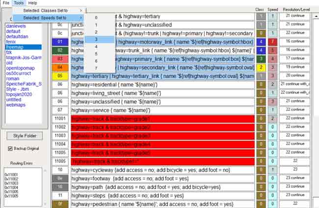
- Highlights type numbers which cannot be used for routing - see below.
- Improved load and save options enabling backups of lines file.
- Set Selected routes / speeds to a certain value to allow for experimentation and see the effect in Basecamp:
ie what happens if all my speeds were set to the same value etc
Go Tools - Option to backup original lines file
Use CTRL A to select All
Use Shift mouse click to select some
Use CTRL mouse click to select/deselect one
Use Esc to deselect all
 |
Improved Route Editor 3 |
No Spam No Junk added
Download Route Editor 3 for Windows
What does road_class mean?
This makes a line routable and can be part of an address search.
Class refers to Length of Highway, not to it's physical properties.= (ie muddy, tarmac)
| highways | used for | |
| 0 | most | Local Traffic and Residential / Service Roads / Tracks / Paths |
| 1 | most | Roundabouts |
| 2 | some | Roads that connect within a Region / Province. Arteries from a Town/City |
| 3 | few | Roads that connect large Regions / Provinces |
| 4 | very few | Roads that connect Countries or Large distances, ie motorways / autobahnen |
- For best results add the ' --remove-short-arcs ' option when running mkgmap
It ensures some tight turnings have been removed.
Even for hiking modes Garmin's algorithm avoids routes with any tight turnings - It is important for routing to work well that most roads are class 0 and there are fewer and fewer roads in each of the higher classes.
- Giving all highways a 4 road_class not only affects routing , it also overloads the section reserved for boundary nodes.
- You can use mkgmap:road-class to override a class,ie increase or decrease it's value.
ie : highway= trunk {set mkgmap-class=3}
What does road_speed mean?
| Speed | |
| 0 | 3 mph / 5 kmh |
| 1 | 15 mph / 20 kmh |
| 2 | 25 mph / 40 kmh |
| 3 | 35 mph / 60 kmh |
| 4 | 50 mph / 80 kmh |
| 5 | 60 mph / 90 kmh |
| 6 | 70 mph / 110 kmh |
| 7 | No speed limit |
- . It is an indication of how fast traffic on the road is. 0 is the slowest and 7 the fastest.
- This is not a speed limit and does not activate the maximum speed symbol on the newer Garmin car navigation systems.
- You can use mkgmap:road-speed to override a given speed
highway=secondary & contstruction=* {set mkgmap-speed=3}