
Resolution Plotter
Enabling smooth zooming in and out of maps
Default Style
 |
 |
| Boundaries | Places |
 |
 |
| Highways | Areas |
How to select your style folder
Click >> button and locate your \styles folder NOT your style
How to add a TYP file
Go File,Open,Add TY file or double click on TYP label on main screen
The typ file must be in .txt format
Using Search
Tick 'Inc' box if you wish to search files which are linked using the inc option ion your style sheet.
When using the text search option you can narrow down your investigation:
'Include Option'
Tick this option if you want to include your text search
example: show me highways with some form of 'access'.
Tick highway
Tick Include
Add access to the text box
How to start:
A Define sequence
- Start from Basecamp / Mapsource and set your map-detail to Medium
- Select a map and zoom out until you just see a small area then gradually zoom in and notice what appears first.
- We suggest the following order : Boundary - Place - Highway - Area
1) This means places do not appear before you have an outline of a country - they may appear at the same level as in the Default style - see above , both start at resolution 12.
2) Highways do not appear before certain places, ie capital (large) cities
3) Areas should not appear before highways, except for sea and land
B Determine a sequence for boundaries, places ,highways and areas
What boundaries are important?
What constitutes an important city? How do we define this in mkgmap? Default style uses 'population'
C Like Garmin , use thinner lines for lower resolution values
Have at least 2 lines for motorways & primary roads
To make the transition smooth do not use bitmap lines or bitmap polygons for low resolutions; instead set them to solid.
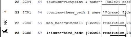 |
All 0x2c points ONLY appear In Mapsource/Basecamp at resolution 24 Viewpoints, Theme_parks, Wind mills & bird hides will therefore not appear at resolution 22 or 23 unless you make the 2c's transparent and add an extra icon with the required resolution |
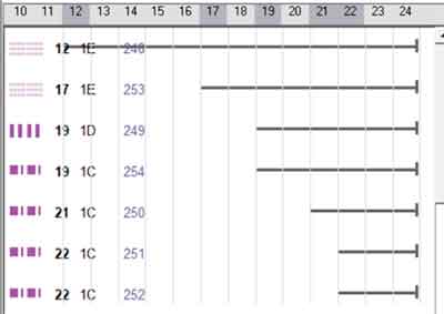
How to detect Dead Code
Dead code means any code which mkgmap never parses
It is easier to detect dead code when you select one option, ie
Select a particular highway.
Make sure the 'sort' option is unchecked.
Click Check button
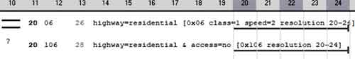
If a resolution line ends with a small stroke (code contains no 'continue') then anything below this line must have a different 'condition'
Example:
highway=residential [0x06 class=1 speed=2 resolution 20-24]
highway=residential & access=no [0x106 resolution 20-24] # dead code
 |
| Dead Code |
As it happens, 0x106 has a '?' for an icon, meaning the TYP file does NOT contain 0x106
How to Customise your Options
All options (line,points,polygons) are found in the /system folder
ie
<mkgmap>lines</mkgmap>
<tag>Highway,Motorway,Trunk,Primary,..... >/tag>
Only the 'tag' tag can be altered
A maximum of 20 tags are allowed.
Download Resolution Plotter