 |
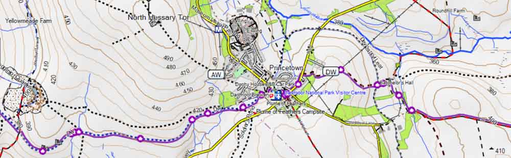
| Free Garmin Map of Southwest with footpaths & long distance hiking routes. |
 |
| FREE UK hiking maps for Garmin GPS devices & watches Includes Dartmoor and Exmoor,Lake & Peak Districts,Scotland & Wales |
Pet Tracking Devices
You can now track your Dog using a mobile , PC or certain GPS devices.
For more information search for
'Pet Tracking devices'.
Do check reviews for range , durability, water resistance and subscription fees.
How does a handheld GPS (sat-nav) work ?
Getting the Best from Your GPS
When you switch on your GPS, it begins searching for satellites to determine your location. This can take up to two minutes, depending on factors such as your surroundings (e.g. being between buildings or trees), your activity (moving or stationary), and even the weather.
Tip: To speed up satellite acquisition, turn on your device and place it on your car dashboard — open sky above helps a lot!
Extra Help: Enabling EPO (Extended Prediction Orbit) downloads can also reduce the time it takes to get a fix.
On many devices, you can improve GPS accuracy by selecting additional satellite systems like GLONASS, GALILEO, or WAAS/EGNOS.
To ensure the best reception:
- Avoid standing between tall buildings or dense trees.
- Try to remain stationary while your GPS acquires satellites.
Surprisingly, in our experience, Sundays often yield poorer accuracy, almost as if the satellites are taking a day off!
Once the necessary satellites are found, your GPS will automatically re-centre the map around your current location. If the screen appears blank, it may mean:
- Your device doesn’t have map data for your area, or
- You may need to zoom in to see the map details.
You’ll typically follow a track (usually in GPX format) saved on your device. This track appears as a highlighted line superimposed on your map.
When you start navigation, your GPS will notify you if you're on or off track.
Be aware that poorly created tracks can give the impression of a path running through buildings or dense forests!
Most tracks aren't 100% accurate, and GPS precision is often within 3 meters — with experience, you’ll learn to mentally filter out these small inaccuracies.
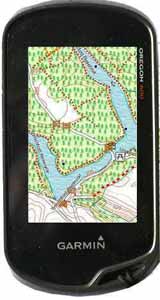
Note: The OS50 map isn't ideal when accuracy is crucial. If you're using a Garmin device, you're in luck — high-quality, free OSM maps are readily available and much more detailed - - see example.
| Which Way? |
Why Use a handheld GPS for walking?
Yes, your smartphone does have GPS — but it's not always up to the task when you're out walking in the countryside
Here’s why handheld GPS devices are still worth considering:
Why Phones Fall Short:
- Limited sensitivity & accuracy — especially in dense forests or remote areas.
- Lack of detailed maps — many phones don’t show footpaths, bridleways, or lesser-known trails.
- Screen visibility — smartphones often suffer from sun glare, making them hard to read outdoors.
The Case for a Handheld GPS
: A handheld GPS isn't essential if you're walking in a region with clearly marked trails and signs. But, when you’re:
- Crossing vast forests or open fields,
- Navigating farmland with barking dogs or curious cows,
- Unsure where the next stile or gate is... ...
the reassurance of an arrow pointing the way can be a real comfort.
Safety & Convenience
- : Always shows your exact location and ETA — vital in an emergency.
- Can help navigate through towns and cities, guiding you to a specific point of interest (pub, café, shop… even a loo!).
Why Not Use a Car Sat Nav?
- Not designed for footpaths or trails.
- Awkward to carry.
- Most don’t let you follow a custom route you've planned on your computer.
What a Walking GPS Can Do
- : Follow circular or custom routes with ease.
- Track your exact journey, including any deviations or detours.
- Export your route to view later in Google Earth or other mapping software.
A Middle Ground
: Apps like OSMAnd (based on TOPO maps) are a great option for mobile users — they offer good detail, including paths and tracks.
What are the best sat-navs / gps devices for walkers?
Check out the best handheld Satnavs for walking