Culmstock Walks ambling through the peaceful Blackdown Hills
Culmstock , split by the river Culm, is joined by an impressive 5 arched bridge dating from the Middle Ages.
The village had a long tradition of cloth making with the
Fox Brothers building a mill here in 1822 to spin yarn.Part of a mill can still be seen from Blackwater Road, just past the village hall.
The Church and Yew Tree - see below
The Old Bridge
Disused Railway
Old Mill
The Church and Yew Tree - see below
The Old Bridge
Disused Railway
Old Mill
Walk 1
| Walk 1 Culm Valley (2.8 miles) | Time:1h 10 mins |
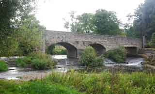 Culmstock Bridge | 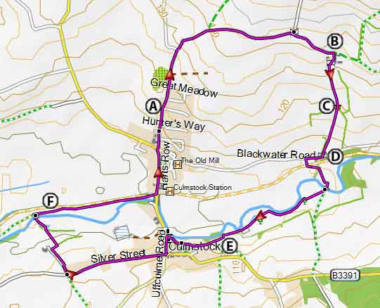 Tap map for larger version | ||
| The Church and Yew Tree - see below The Old Bridge Disused Railway Old Mill | |||
| Culmstock residential parking , Hunter's Hill | |||
This fairly easy river walk includes a steady climb and descent. There are two bridges with steepish steps. A Go up Hunters Hill with primary school on your left. Continue past the new recreation grounds, also on your left. At a road sign for Woodgate & Beacon , take the right fork. B Continue for 790 m until - just after a bungalow on your right and before a farm - turn right onto a grassy path. If you have gone into the farm you have gone too far! Follow this path , through a white gate standing almost on its own. Bear left keeping in line with the house you have passed until you reach the corner of a hedge C Here you will notice a gap with a stile. Continue descending until you see a gate at the bottom with hedge on right. D Turn right , then , almost immediately after house, turn left and follow footpath signs to the river. Cross bridge and turn right keeping river on your right. Aim towards the church. E Keep slightly to the left to a gate then up some steps . Look out for a yew tree sprouting out of the church tower ! It dates back to around 1750.After 470 m where you meet a track on left and a drive to Woodhayne Barton on right turn right and take the footpath on right of drive. Follow this to the river. Cross river and turn right , F Caution: aim towards a line of trees (an abandoned railway line) on your left - you can walk along the river for a short while but not all the way! Keep trees on left until you join a track and follow the track until you reach Culmstock's bridge. Culmstock residential parking , Hunter's Hill | |||
| Show on Google Earth | |||
| GPX for GPS | |||
| How to view a GPX file |
| Walks near Culmstock: | |
| Hemyock | |
.jpg) | Although the walk contains one of the steepest climbs, the views and the well marked footpaths through rolling and remote landscapes make it a most enjoyable experience. |
| Uffculme | |
.jpg) |
A delightful and gentle walk following a well defined footpath along the river Culm |
| Burlescombe | |
 | A delightful and easy walk using part of the Grand Western Canal to Holcombe Rogus - Holcombe means Wooden Valley. |
Walk 2
| Walk 2 Culmstock to Culmstock Beacon (3.9 miles) | Time:1h 40 mins |
Beacon | 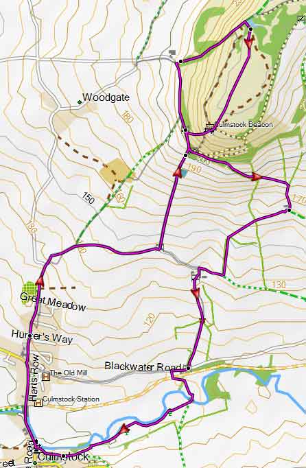 Tap map for larger version | ||
Extensive views of the village and beyondThis delightful and somewhat invigorating walk starts from the village and steadily climbs up to the Beacon. It follows quiet lanes,public footpaths & bridlepaths. The beacon was used to spot enemies, ie the Armady ships .A fire would be lit to raise the alarm. Download route for GPSSee on Google Earth There is one steady climb. | |||
| Show on Google Earth | |||
| GPX for GPS | |||