
Showing OSM data on Google Earth
OSM2GE Beta is a osm2kml GUI that can project osm files onto Google Earth. It has been successfully tested with files up to 15 mb though the larger the files,particularly those containing numerous buildings, the slower GE will respond. You will also need to install Google Earth on your PC.
A low level random distortion of all the coordinates and their elevation ensures that Google Earth is not presenting osm data accurately .
Depending on the tiles,Google Earth is not updated as frequently as OSM and can therefore provide interesting historical data .
For a more detailed description download the manual:
 |
|
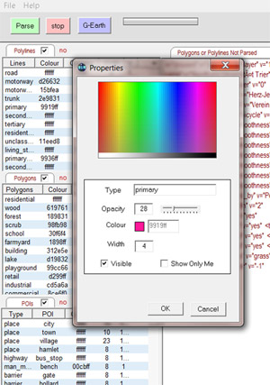
Colour of Polygons and Lines
By default the Mapnik colour scheme has been adopted but you can select a different colour for each type of polygon or highway (line). Different styles can be created.
Opacity
You can also edit the opacity of each type. Results are saved for future use.
Width
Again, the line width or each highway as shown on Google Earth can be changed to suit your own preferences.
Visibility
You can set the visibility for each poi,polygon or line.
Unrendered data
Some osm data will not be rendered in Mapnik, ie hedges,themeparks and various amenities etc. OSM2GE lists such data and provides the necessary editing tools to make them appear on Google Earth.
'Show me all the restaurants in this area'
You can decide to show just one type of poi, as seen in the picture below. You can also select fontsize and colour.