Salcombe Hill enjoy a picnic with spectacular views
Salcombe Hill offers the walker spectacular views of Sidmouth , Dunscombe Cliff and the Jurassic coastline.
How to get there :
Take the Salcombe Hill road from Sidmouth and follow brown signs to the Norman Lockyer Observatory. At the Top of the hill ,take car park on right.
Take the Salcombe Hill road from Sidmouth and follow brown signs to the Norman Lockyer Observatory. At the Top of the hill ,take car park on right.
Walk 1
| Walk 1 to cliff top (1.2 miles) | Time:30 mins |
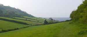
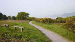 Overlooking Sidmouth | 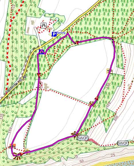 Tap map for larger version | ||||||||
| Free Car Park more or less opposite the Norman Lockyer Observatory | |||||||||
| see main parking area | |||||||||
This easy walk follows a well defined path to the top of the cliff where it joins the South West Coast Path. From here turn east and follow the coastal path towards Branscombe. Go through the first kissing gate then continue until the next kissing gate. Just before before a kissing-gate. take a path on left. it is worth going through the gate just to admire the view of Dunscombe Cliff. Once in the woods take a left path to return to the Car Park - it is well signed. No steep hills to climb or descend ! | |||||||||
| Show on Google Earth | |||
| GPX for GPS | |||
| How to view a GPX file |
| Walks near Salcombe Hill: | |
| Sidmouth West | |
.jpg) | Popular walks combining forests,moorland and sea with breathtaking views of the Jurassic coast. |
| Branscombe | |
.jpg) | This is a must do walk if you are in this area - it will involve some climbing but views of coastline are breathtaking. |
| Donkey Sanctuary | |
.jpg) | A short but invigorating family walk from the Donkey Sanctuary to the Jurassic Coast where in 2007 the Napoli ran aground. |
Walk 2
| Walk 2 cliff top and Salcombe Regis (2.5 miles) | Time:1h 10 mins |
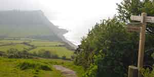 Jurassic Coast | 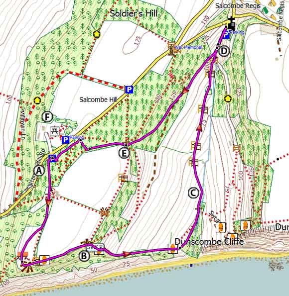 Tap map for larger version | ||
This is a most rewarding but very strenuous walk as it includes a steep 59 step descent. There is no pub or shop at Salcombe Regis. A Follow the walk 1 instructions to the kissing gate. B Carefully descend (use the benches to pause and admire the views) At the bottom , the path curves to the left following a stream. C Ignore a footpath across the stream but continue inland. along a public footpath & climbing steadily towards Salcombe Regis. Continue along this footpath . When it joins a lane continue in the same direction until you reach the church on right. The church has its origin in the 10th century when it was constructed from wood. It has a beautiful ancient 'eagle' lectern carved from a single block of wood At the top of the village stands the Salcombe Thorn (mentioned in the Domesday book) which once acted as a Saxon boundary marker. D Retrace steps and take track on right. Follow the track for 0.2 miles then up a path on right. E Follow sign to car park FNorman Lockyer Observatory & picnic area.Download route for GPSSee on Google Earth From the carpark cross Salcombe Hill into a track beside the observatory. Halfway, turn right through a small gate and into the grounds of the Norman Lockyer Observatory - you can have your picnic here! Lockyer used the telescope toe measure the sun's surface temperature ; he discovered and new element and named it Helium (from the Greek 'helios' ήλιος meaning 'sun') | |||
| Show on Google Earth | |||
| GPX for GPS | |||
 |